Navigation Sector
A navigation sector is a cuboid-shaped navigation area that enables the following:
- Both the 2D and 3D routes can be calculated within navigation sectors.
- In case of the 2D routes, a point moves in the lower plane of the navigation sector (Z coordinate is not taken into account). If the height or radius set for this point is greater than the size of the navigation sector, such sector will be discarded from pathfinding.
- In case of the 3D routes, a point moves in 3 dimensions. If the radius set for this point is greater than the size of the navigation sector, it will be discarded from pathfinding.
- Routes can be calculated within several intersecting navigation sectors. The intersecting sectors will be treated as a single navigation area.
NoticeIn case of the 2D routes, the height difference between the intersecting sectors must not exceed the maximum height set for the 2D route; otherwise these sectors will be discarded from pathfinding.
See also
- The NavigationSector class to edit navigation sectors via UnigineScript
- The PathRoute class to create 2D and 3D routes inside navigation sectors
- The article on Creating Routes
- A set of samples located in the data/samples/paths folder:
- route_00
- route_01
- route_02
- sector_00
- sector_01
- sector_02
Creating Navigation Sector
To create a navigation sector via UnigineEditor:
- Run UnigineEditor.
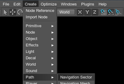
- On the Menu bar, click Create -> Path -> Navigation Sector.

- Click somewhere in the world to place the navigation sector.
A navigation sectorThe new navigation sector will be added to UnigineEditor and you will be able to edit it via the Nodes panel.
Notice
The created navigation sector only provides an area within which the 2D and 3D routes are calculated. The routes themselves should be created from the script.
Editing Navigation Sector
On the Navigation tab of the Nodes panel, you can adjust the following parameters of the navigation sector:

| Navigation | Navigation mask. The navigation mask of the navigation sector must match the navigation mask of the route that is calculated within it. Otherwise, the sector will not participate in pathfinding. By using the navigation mask, you can specify sectors that must be ignored during pathfinding. |
|---|---|
| Quality | Quality of optimization of the route that has already been calculated. This value specifies the number of iterations that are used for taking the short cut. The higher the value, the longer the route calculation will take. |
| Velocity | Scaling factor for velocity of the point that moves inside the navigation sector along the calculated route. |
| Dangerous | Danger factor that indicates if the point that moves inside the sector should try to avoid the navigation sector.
Notice
If the danger factor exceeds the maximum danger factor set for the route, the navigation sector will be excluded from pathfinding calculations. |
| Size | Size of the navigation sector's box along the axes. |
Last update: 20.10.2017
Помогите сделать статью лучше
Была ли эта статья полезной?
(или выберите слово/фразу и нажмите Ctrl+Enter
