IG 编辑器插件
The IG Editor Plugin allows you to adjust the weather properties for IG right in the Editor.IG 编辑器插件允许您调整天气属性IG就在编辑器中。
To make the plugin available in the Editor:要使插件在编辑器中可用:
- Create a new project with an IG template via SDK Browser.
创建一个新项目IG template通过 SDK 浏览器。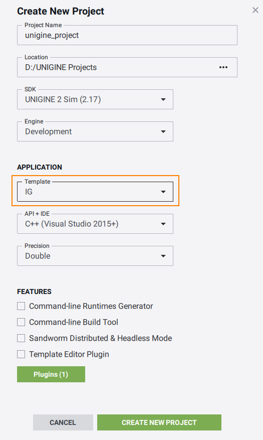

- Open the plugin windows via Tools->Image Generator Plugin.
通过打开插件窗口Tools->Image Generator Plugin.

The IG Editor Plugin provides the following features.IG Editor Plugin 提供以下功能。
Geodetics大地测量学#
This window outputs current coordinates in the geodetics format.此窗口以大地测量格式输出当前坐标。

- DataBase Origin — origin of the world (not editable)DataBase Origin - 世界的起源(不可编辑)
- Camera — camera geopositionCamera - 相机地理位置
- Current Node — geoposition of the selected nodeCurrent Node - 所选节点的地理位置
Reload Geodetic System重新加载大地测量系统#
The Reload Geodetic System button recalculates the origin coordinates for the world. It is useful when the terrain or the geodetic pivot position was changed. In such cases the manual reload of the geodetic system is required to make the window show the new correct coordinates.Reload Geodetic System 按钮重新计算世界的原点坐标。当地形或大地测量枢轴位置发生变化时,它很有用。在这种情况下,需要手动重新加载大地测量系统以使窗口显示新的正确坐标。
DateTime约会时间#
Allows to set up the date and time parameters which affect the sky and world illumination due to stars, Sun, and Moon position change.允许设置日期和时间参数,这些参数会因星星、太阳和月亮的位置变化而影响天空和世界照明。

- DateTime — sets the current date and timeDateTime - 设置当前日期和时间
- Timezone — sets the current UTC time zone for the date and time (e.g., for the UTC-3:30 timezone the value will be equal to -3.5)Timezone - 为日期和时间设置当前 UTC 时区(例如,对于 UTC-3:30 时区,该值将等于 -3.5)
- Continuous Time — enables or disables the passage of time Continuous Time - 启用或禁用时间流逝
- Sun — enables the sun and its light rendering and sets brightness intensitySun - 启用太阳及其灯光渲染并设置亮度强度
- Moon — enables the moon and its light rendering and sets brightness intensityMoon - 启用月亮及其灯光渲染并设置亮度强度
- Stars — enables the stars rendering and sets their brightness intensityStars - 启用星星渲染并设置它们的亮度强度
Buttons纽扣#
- Show Sun Node — selects the sun node in the World Nodes windowShow Sun Node - 选择 World Nodes 窗口中的太阳节点
- Show Moon Node — selects the moon node in the World Nodes windowShow Moon Node - 在 World Nodes 窗口中选择月亮节点
- Save — saves the data, time, and timezone to configuration fileSave - 将数据、时间和时区保存到配置文件
Meteo天气预报#
The Meteo window provides a way to create regions and layers inside them. By default there is always a Global region present which have an unlimited and non-removable Global layer.Meteo 窗口提供了一种在其中创建区域和层的方法。默认情况下,始终存在一个 Global 区域,该区域具有无限且不可移动的 Global 层。

Regions地区#
A weather region provides a top-down form for the weather map. There are three types of regions supported.一种天气区为天气图提供自上而下的形式。支持三种类型的区域。

Setting Up Region设置区域#
To set up a custom weather region, do the following:要设置自定义天气区域,请执行以下操作:
- Go to Tools->Image Generator Plugin->Meteo.转到 Tools->Image Generator Plugin->Meteo。
- Click Add Region and then press the Edit Region button to start editing the newly created region in the world.
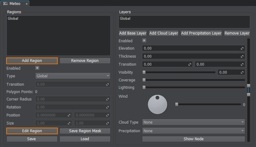 单击 Add Region,然后按 Edit Region 按钮开始编辑新创建的世界区域。

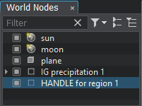
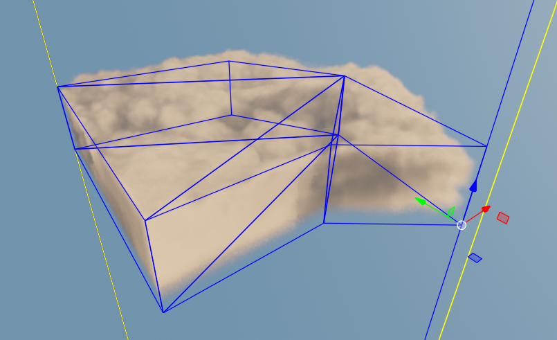
- Select and use handle nodes in the world to specify the region shape (you can add a cloud layer to see the region boundaries more clearly).
-
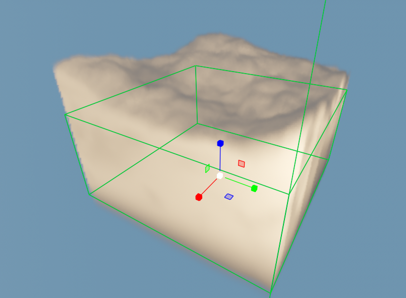
The rectangle shape type supports translation and scale of the rectangle regional area.The rectangle shape type supports translation and scale of the rectangle regional area.
-
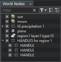
For the polygon shape type the handles can be moved, reordered, added, and deleted. This way you can make a region of any custom shape you require.For the polygon shape type the handles can be moved, reordered, added, and deleted. This way you can make a region of any custom shape you require.
-

The rectangle shape type supports translation and scale of the rectangle regional area.矩形形状类型支持矩形区域的平移和缩放。

-

For the polygon shape type the handles can be moved, reordered, added, and deleted. This way you can make a region of any custom shape you require.对于多边形形状类型,可以移动、重新排序、添加和删除手柄。 通过这种方式,您可以制作所需的任何自定义形状的区域。

-
Editing Regions编辑区域#
The following buttons are provided to setup a region:提供以下按钮来设置区域:
- Add Region — adds a region.Add Region - 添加一个区域
- Remove Region — removes the selected region.Remove Region - 移除选定区域
- Edit Region — enables edit mode for the selected region.Edit Region - 为选定区域启用编辑模式
Saving the Region Configuration保存区域配置#
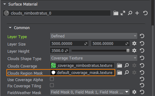
You can save the region via the Save Region Mask button as a texture on a disk, so later it can be used as a Clouds Region Mask value for a defined layer type of various clouds materials.您可以通过 Save Region Mask 按钮将区域保存为磁盘上的纹理,以便稍后将其用作 defined 图层类型的各种云材质的 Clouds Region Mask 值。
Saving and Loading Meteo Presets保存和加载 Meteo 预设#
Meteo Presets store the data about regions with layers and their parameters to a file of special format (*.igmeteo). The IG:Meteo window allows you to use presets the following ways:Meteo Presets 将有关具有图层的区域及其参数的数据存储到特殊格式 (*.igmeteo) 的文件中。 IG:Meteo 窗口允许您通过以下方式使用预设:
- Save — saves the region on a disk as a meteo preset.Save - 将区域保存在磁盘上作为气象预设
- Load — loads the meteo preset from a disk.Load - 从磁盘加载气象预设
Layers图层#
Layers comprise a vertical profile of the region. Various heights can store different cloud or precipitation layers.层包括该区域的垂直轮廓。不同的高度可以存储不同的云层或降水层。

Types of Layers图层类型#
- Base Layer — base layer without any visual representation. Contains only parameters (visibility distance, temperature, humidity, etc.).Base Layer - 没有任何视觉表示的基础层。仅包含参数(可见距离、温度、湿度等)。
- Cloud Layer — layer that describes the clouds.Cloud Layer - 描述云层
- Precipitation Layer — layer that describes the precipitation (rains or snow).Precipitation Layer - 描述降水的层(雨或雪)
Setting Up Layers设置图层#
To add a new layer to a region, do the following:要将新图层添加到区域,请执行以下操作:
- Select the region in the left Regions list and click the required Add Layer button.
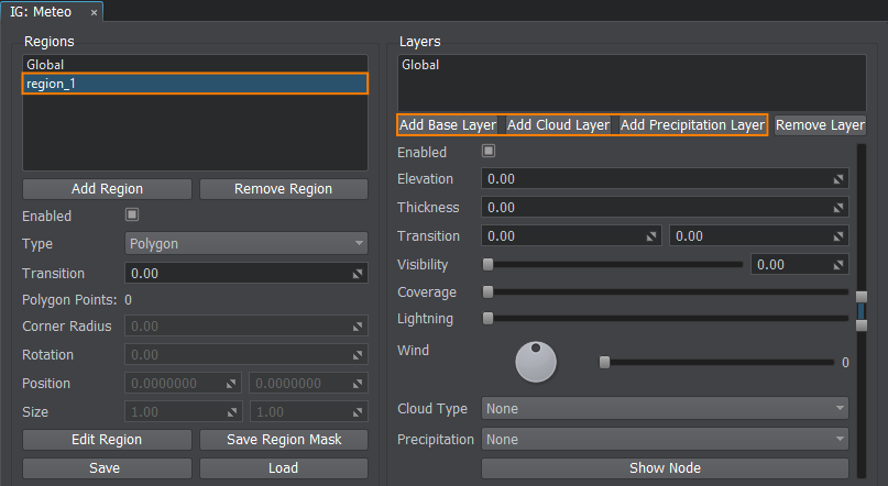 在左侧 Regions 列表中选择区域,然后单击所需的 Add Layer 按钮。

- Increase the Coverage parameter to make the layer affect the weather.增加 Coverage 参数,使图层影响天气。
- Set the Elevation and Thickness parameters to adjust the layer's height and size (in meters).

You can use the scroll manipulator to set the elevation and thickness parameters visually (changes will be reflected in the viewport). 设置 Elevation 和 Thickness 参数来调整图层的高度和大小(以米为单位)。

您可以使用滚动操纵器直观地设置高程和厚度参数(更改将反映在视口中)。
- Depending on the type of the layer (base, cloud, precipitation), you must specify its properties.根据图层的类型(基础、云、降水),您必须指定其属性。
- In order to see the cloud/precipitation node in the world, click the Show Node button.要查看世界中的云/降水节点,请单击 Show Node 按钮。
- If you want to delete the added layer, select it and click the Remove Layer button.如果要删除添加的图层,请选择它并单击 Remove Layer 按钮。
Cloud Types云类型#
Specifies the type of cloud for the given layer. Can be one of the types specified for this project via the Cloud Types window.指定给定层的云类型。可以是为此项目指定的类型之一Cloud Types窗户。
Upon selection of a cloud type the recommended parameters are automatically set for this type of clouds.选择云类型后,会自动为此类云设置推荐参数。
Setting Up Clouds设置云#
To start adjusting clouds in the corresponding layer, select it in the Layers list and specify the required Cloud Type.要开始调整相应图层中的云,请在 Layers 列表中选择它并指定所需的 Cloud Type。

Use the Coverage parameter to make clouds appear and stand out in the sky.使用 Coverage 参数使云出现并在天空中突出。
Precipitation沉淀#
Specifies the type of precipitation:指定降水类型:
- -1: None — no precipitation is set for this layer-1:None - 没有为此层设置降水
- 1: Rain — raindrops1: Rain - 雨滴
- 2: Snow — snowflakes2: Snow - 雪花
Setting Up Precipitations设置降水#
To start adjusting rain or snow precipitations in the corresponding layer, select it in the Layers list and specify the required Precipitation Type.要开始调整相应图层中的雨或雪降水,请在 Layers 列表中选择它并指定所需的 Precipitation Type。
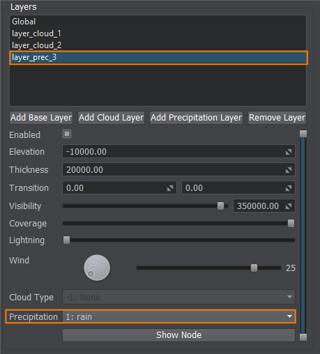
Don't forget to increase the Coverage parameter to make precipitation appear and stand out in the viewport.不要忘记增加 Coverage 参数以使降水出现并在视口中突出。
Lightning闪电#
To adjust the lightning appearance for the corresponding layer, select it in the Layers list and specify the required frequency of lighting spawn.要调整相应层的光照外观,请在 Layers 列表中选择它并指定所需的光照生成频率。
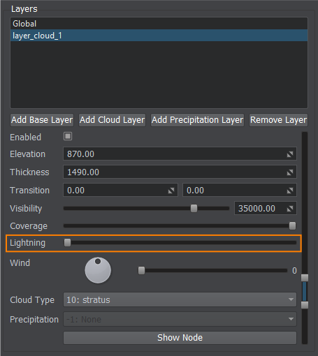
The maximum frequency that can be set via the IG Editor Plugin is once per second.可以通过 IG Editor Plugin 设置的最大频率是每秒一次。
Wind风#
Specifies wind properties for this layer by setting the direction and force of the wind.通过设置风的方向和力量来指定该层的风属性。
- Direction — wind direction inside the layerDirection - 层内的风向
- Wind Force — force of the wind for the layerWind Force - 层的风力

Cloud Types云类型#
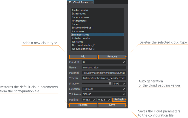
This window describes all types of clouds available in IG:此窗口描述了 IG 中可用的所有类型的云:
- 1: altocumulus
- 2: altostratus
- 3: cirrocumulus
- 4: cirrostratus
- 5: cirrus
- 6: cumulonimbus_1
- 7: cumulus
- 8: nimbostratus
- 9: stratocumulus
- 10: stratus
- 12: cumulonimbus_2
- 13: cumulonimbus_3
Adjusting Clouds调整云#
Via this window you can add your own custom types of clouds or change the default ones. The following parameters are available:通过此窗口,您可以添加自己的自定义云类型或更改默认类型。以下参数可用:
- Cloud ID — ID of the cloud in the listCloud ID - 列表中云的 ID
- Name — cloud nameName - 云名称
- Material — cloud materialMaterial - 云材质
- Tracker — cloud track used for coverage changing Tracker - 用于覆盖变化的云轨道
- Shadow — power of the shadow cast by this cloudShadow - 这朵云投射的阴影的力量
- Elevation — default elevation for this type of cloud (height above sea level)Elevation - 此类云的默认高度(海拔高度)
- Thickness — default thickness for this type of cloud Thickness - 这种云的默认厚度
- Padding — lower and upper bound for this type of cloudPadding - 此类云的下限和上限
To understand the parameters' meaning, check the diagram below.要了解参数的含义,请查看下图。

Clouds list and parameters are saved to the ig_config.xml file, so it can be restored and used in other instances of IG.云列表和参数保存到 ig_config.xml 文件中,因此可以在 IG 的其他实例中恢复和使用。
本页面上的信息适用于 UNIGINE 2.19 SDK.
